
 |

|
| ActiveWin: Reviews | Active Network | New Reviews | Old Reviews | Interviews |Mailing List | Forums |
|
|
|
|
|
DirectX |
|
ActiveMac |
|
Downloads |
|
Forums |
|
Interviews |
|
News |
|
MS Games & Hardware |
|
Reviews |
|
Support Center |
|
Windows 2000 |
|
Windows Me |
|
Windows Server 2003 |
|
Windows Vista |
|
Windows XP |
|
|
|
|
|
|
|
News Centers |
|
Windows/Microsoft |
|
DVD |
|
Apple/Mac |
|
Xbox |
|
News Search |
|
|
|
|
|
|
|
ActiveXBox |
|
Xbox News |
|
Box Shots |
|
Inside The Xbox |
|
Released Titles |
|
Announced Titles |
|
Screenshots/Videos |
|
History Of The Xbox |
|
Links |
|
Forum |
|
FAQ |
|
|
|
|
|
|
|
Windows XP |
|
Introduction |
|
System Requirements |
|
Home Features |
|
Pro Features |
|
Upgrade Checklists |
|
History |
|
FAQ |
|
Links |
|
TopTechTips |
|
|
|
|
|
|
|
FAQ's |
|
Windows Vista |
|
Windows 98/98 SE |
|
Windows 2000 |
|
Windows Me |
|
Windows Server 2002 |
|
Windows "Whistler" XP |
|
Windows CE |
|
Internet Explorer 6 |
|
Internet Explorer 5 |
|
Xbox |
|
Xbox 360 |
|
DirectX |
|
DVD's |
|
|
|
|
|
|
|
TopTechTips |
|
Registry Tips |
|
Windows 95/98 |
|
Windows 2000 |
|
Internet Explorer 5 |
|
Program Tips |
|
Easter Eggs |
|
Hardware |
|
DVD |
|
|
|
|
|
|
|
ActiveDVD |
|
DVD News |
|
DVD Forum |
|
Glossary |
|
Tips |
|
Articles |
|
Reviews |
|
News Archive |
|
Links |
|
Drivers |
|
|
|
|
|
|
|
Latest Reviews |
|
Xbox/Games |
|
Fallout 3 |
|
|
|
Applications |
|
Windows Server 2008 R2 |
|
Windows 7 |
|
|
|
Hardware |
|
iPod Touch 32GB |
|
|
|
|
|
|
|
Latest Interviews |
|
Steve Ballmer |
|
Jim Allchin |
|
|
|
|
|
|
|
Site News/Info |
|
About This Site |
|
Affiliates |
|
Contact Us |
|
Default Home Page |
|
Link To Us |
|
Links |
|
News Archive |
|
Site Search |
|
Awards |
|
|
|
|
|
|
|
Credits |

|
Product: MapPoint 2002 Company: Microsoft Website: http://www.microsoft.com Estimated Street Price: $249.95 Review By: Julien Jay |
Advanced Features
|
Table Of Contents |
The automation model of MapPoint 2002 has been greatly enhanced so developers can get even more out of MapPoint when using its component in their own solutions. MapPoint 2002 comes with a reference guide that explains to developers the properties & methods of the MapPoint objects. We regret the fact that MapPoint 2002 still doesnít include Visual Basic for Applications that would have further simplify the customization of the software by avoiding using external programming language. Anyway you can now automate almost every MapPoint task like: drawings, toolbars, find and location, routing and driving directions, selection, window management, page setup and printing, full Clipboard support, demographics and the MapPoint ActiveX control.
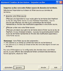
One of the new flagship features of MapPoint 2002 is the territories wizard. Whatís a territory youíll ask? Well a territory is a group of geographic units a user can define and use to represent any type of information. This feature will be most likely used to analyze sales figures per region. But you can also use them to represent delivery areas, service coverage areas, marketing regions, etc. MapPoint 2002 offers an original new feature dubbed DTZ (Drive Time Zones): after youíve put a point on the map DTZ will show how far you can go from that point within a specified time (1 to 999 minutes). The result is that a myriad of blue points will appear around the centre point youíve defined: once DTZ is done you can change the position of each points. However in a big town this feature is useless, or at least give inconsistent results, since the software doesnít take in account the frequent traffic jams that affect the circulationís fluidity.
Microsoft
MapPoint 2002 New Territories Wizard (click to enlarge)
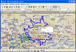
Drive Time Zones: 10
minutes around a point defined in London (click to enlarge)
We have listed above the various map types MapPoint offers. New to the release 2002 of MapPoint is a wide variety of map styles like: Multiple Symbol, Pie Chart, Sized Pie Chart, Column Chart, and Series Column Chart maps. Once you have mapped your data, you can change its appearance on the map and customize the various legends in order to communicate the meaning of your data. As youíve guessed you can now map data with charts so you can add bar or pie charts to your map with the aim to better illustrate data. Microsoft MapPoint 2002 supports GPS (Global Positionning System) devices thanks to the NMEA (National Marine Electronic Association). That way you can link a GPS to your laptop while youíre on the road to make sure you stay on the right track. Once a GPS is linked to the PC MapPoint 2002 can even display the longitude & latitude coordinates.
To be complete we have to mention that the US edition offers a ĎLiveUpdateí like feature so you can instantly get the latest map updates (like road constructions, deviations, etc) over the Internet. The US edition of MapPoint also displays speed limits and turn restrictions available for each road so the estimation a trip will take and the driving directions are much more accurate.
Importing data
MapPoint 2002 can easily show specific data that come from other software onto a map. The Importing data wizard simplify the data importing process that come from various sources such as Microsoft Excel, Microsoft Access, Microsoft Outlook SQL Server or even text with separators file so you can represent onto a map sales performance market potential & trends. The Outlook support let you import your list of contacts and place them on a map to localize them. For other data kind, MapPoint 2002 will use Microsoft Access to turn them into a compliant MapPoint format. When users introduce new data in the system, MapPoint 2002 will automatically analyze them to distinguish columns with geographical related contents. Data can be imported by address, zip code, state, country or another criterion. Then the wizard will suggest different ways to show data on the map: if these representation possibilities arenít liked by user it is possible to define the way data should be shown on the map. Afterward the wizard will analyse each data and put them onto the map: theoretically MapPoint 2002 should be able to put on the map 80% to 90% of the data if we take care of incomplete addresess and other causes that give the localization to be impossible. Itís a great advantage since competitorís software can only correctly import and place onto the map 55% to 65% of the data. When MapPoint canít place data on the map it offers users approximate values and prompts to choose the correct one. At the end of the process MapPoint shows every record that werenít recognized or converted on the map. Data can also be linked between software so if you change a date in Excel, the whole map will be rebuilt under MapPoint to reflect the latest changes.
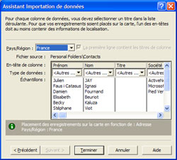
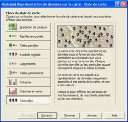
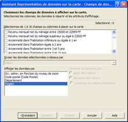
Importing Data
Wizard (click to enlarge)
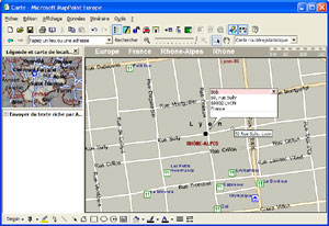
Contact Put On
Map Via The Import Wizard (click to enlarge)
Demographic Data
![]() Microsoft MapPoint 2002 comes with
built-in demographic data provided, for the European version, by Claritas.
That way, users can easily map up-to-date demographic data on the countries
or areas they wish to prospect to reflect the potential of those areas. To
do so, MapPoint 2002 offers an easy-to-use wizard that let them choose among
70 different demographic variables like: population, surface, various levels
of income, age of the population, number of family members, current job,
etc. Then the wizard will automatically represent data on the map using a
style previously defined by the user. The process is painless, fast and the
result will really show you new trends thus helping targeting new potential
customers as well as refining your decisions.
Microsoft MapPoint 2002 comes with
built-in demographic data provided, for the European version, by Claritas.
That way, users can easily map up-to-date demographic data on the countries
or areas they wish to prospect to reflect the potential of those areas. To
do so, MapPoint 2002 offers an easy-to-use wizard that let them choose among
70 different demographic variables like: population, surface, various levels
of income, age of the population, number of family members, current job,
etc. Then the wizard will automatically represent data on the map using a
style previously defined by the user. The process is painless, fast and the
result will really show you new trends thus helping targeting new potential
customers as well as refining your decisions.
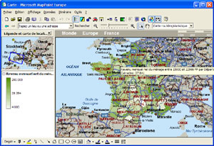
Microsoft
MapPoint 2002 Showing Various Level of Income (click to enlarge)
Exporting Data
MapPoint 2002 lets you export your data only in direction of Microsoft Excel. To proceed you have to simply select the area of the map that contains the data you want to export. MapPoint 2002 can even export data contained in a circle you have drawn on the map. Exporting data from MapPoint can be very useful to invite all your customers that are located in a 40 kilometers range from your building. However you can only export data you have imported first: that means you canít export into Excel the list of fine restaurants of a specific location.
Microsoft Pocket Streets 2002
MapPoint 2002 is provided with the Windows CE version of Microsoft Streets. This small applet which you can install on a pocket PC in a matter of seconds allows users to view the maps they have created under MapPoint 2002. To do so they have to download the map onto their Pocket PC. Itís an essential feature that every Pocket PC user will surely love.
| ę Features | Conclusion Ľ |
